***WE HAVE MOVED TO A NEW WEBSITE. You will be automatically redirected to our new location in 5 seconds.
Showing posts with label warmer. Show all posts
NAM model showing high pressure
dominating the weather into the weekend.
High pressure building into the forecast area will be the main story through the the middle of next week, and to be honest we couldn't ask for a better forecast through the entire period. Although the airmass will still be cool to start the weekend on Saturday, we have a lot to look forward to. A large ridge in the mid and upper levels of the atmosphere will develop over the Central and Eastern United States by Sunday through Wednesday, bringing us fair weather. Plenty of sun, light winds, and splendidy crisp autumn evenings will almost make the weather a non-factor throughout the next several days. Additionally, the airmass will modify with time (it's coming from Canada, but it's warming as it gets here)...meaning high temperatures should slowly climb from the lower 50's on Saturday, to near 60 on Monday, to possibly the mid to upper 60's on Wednesday. The one thing working against us is the fact that we lose an hour of daylight beginning Sunday Night, when we turn the clocks back one hour. Winter is coming, there's no doubt about that, so we're excited to enjoy the next several days of beautifully comfortably weather that this pattern has to offer.


THE FORECAST...

Today (Sunday): Sunny, high's in the lower to mid 50's. Still pretty cool, with light northwest winds. Highs could stay in the 40's over the interior and higher elevations.

Tonight: Mostly clear, with lows dropping into the 20's and 30's once again inland, but the upper 30's to low 40's in the city and metro area. This will begin a trend of slightly warmer nights continuing into next week.

Article written by JH. Published November 5th, 2011 at 1:36am. Updated November 6th, 11:42am.  Looking for a forecast? See New York Metro Weather's Long Range Forecast for the weekend into next week, or view our Technical Forecast Discussion for the more serious weather enthusiasts. Also, check out our new Forecast Overview tab. For up to the minute details on forecasts, watches, warnings, and alerts, follow us on Twitter and Facebook.  
NAM model showing vast high
pressure in control this weekend
A ridge of high pressure has build into the area, and the warming trend is on over the next few days. If you're just waking up and getting a check of the forecast you certainly won't feel the warmth. Such is protocol this time of year under high pressure with clear skies and light winds. The fact is, we're heading towards the colder season and we can't hide that. The overnight period exposes the cool temperatures (in fact, many locations dropped into the 40's and even upper 30's inland on Saturday morning). However, the ridge of high pressure will begin to usher in some of the warmer air of the past few weeks. High temperatures are expected to be in the upper 70's to near 80 in spots on Saturday, and low to middle 80's on Sunday, with some locations possibly topping out warmer than the mid 80's. Make no mistake, this is very warm for this time of year. Don't forget, it's the second week of October! A ridge of the intensity we're experiencing now, in the mid summer, would provide record breaking heat. We'll just have to settle for beautifully pleasant and warm fall weather instead!

THE FORECAST...

Today (Saturday): Mostly sunny, light west winds, high near 79. Couldn't ask for a better start to the weekend. No chance of rain.

Tonight: Clear, temperatures dropping fairly cool once again...but around 10 degrees warmer than Friday Night into Saturday. Low near 61. Again, light and variable winds.

Sunday: Sunny, warmer, light west-northwest winds. High near 85. Gorgeous. Short sleeves and (dare we say it) shorts could actually work during the warm hours of the afternoon.

Article written by JH. Published October 8th, 2011 at 2:22am. Looking for a forecast? See New York Metro Weather's Long Range Forecast for the upcoming weekend, or view our Technical Forecast Discussion for the more serious weather enthusiasts. Also, check out our new Forecast Overview tab. For up to the minute details on forecasts, watches, warnings, and alerts, follow us on Twitter and Facebook. 

NAM model showing the low
pressure out of the picture, and
high pressure building in this week.
Stagnant, slow moving, stalled, blocked, persistent. Those are all words which we have used to describe the upper level low pressure system which sat near or over our area for a good part of the past two or more weeks. Finally, we have only one word to use starting Wednesday: Gone. The storm system is on it's way east of New England, on the move towards a weakness in the pattern which will (finally) allow it to escape to the Atlantic. A ridge and high pressure will then build into the area starting today and continuing through Friday, and not only will the weather be fair, but temperatures will rise towards average and above average as we approach the weekend. In fact, high temperatures could again be approaching 80 degrees by the tail end of the weekend. Still, lets not get too far ahead of ourselves just yet. Today looks to be a gorgeous day, with high temperatures near 70 and mostly sunny skies. A northwesterly breeze and low dew points will have the air feeling brisk, clean, and new, a big change from the past few weeks. We know everybody will be enjoying it! 

THE FORECAST...

Today (Wednesday): Mostly sunny, highs near 70. Northwest winds a bit gusty at times, but we have absolutely no complaints. If you're out very early or very late, bring a light sweater. Otherwise, wear whatever you feel comfortable in 70 degree weather. A beautiful day is on the way. 

Tonight: Cool night, but not as cool as the last few. Low temperatures in the lower to middle 50's in the city, upper 40's inland. Might get a few degrees cooler in spots with good radiational cooling under clear skies. 

ALDS GAME 5 FORECAST..

We've been holding off on the forecast to avoid jinxing our boys in Pinstripes, but the Yankees win tonight ensures that there will be a Game 5 of the American League Division Series played in the Bronx on Thursday Night. Weather has been a significant inhibitor to games thus far during this series--but we have no problems with this forecast. Clear skies, temperatures near 60 around game time. Northwest winds, with temperatures falling into the 50's during the game. It's going to be a crystal clear, crisp October air in place for what promises to be a great night in the Bronx. Go Yankees. For updates on the forecast, check out our Twitter account. 

Article written by JH. Published October 5th, 2011 at 1:05am. Looking for a forecast? See New York Metro Weather's Long Range Forecast for the upcoming work week, or view our Technical Forecast Discussion for the more serious weather enthusiasts. Also, check out our new Forecast Overview tab. For up to the minute details on forecasts, watches, warnings, and alerts, follow us on Twitter and Facebook. 
NAM models forecast highs today
Although the mid and upper level disturbance, which caused the unsettled weather towards the end of last week, is still spinning off to our west, it appears that Monday will be salvaged as a pleasant day. In fact, it could turn out to be one of the warmer days in the area since the big cold front came through just around two weeks ago. Temperatures on Monday, with some breaks in the clouds, are forecast to reach into the upper 70's to near 80, which will feel very warm when coupled with dew points well into the 60's. The humidity won't be helped by a wind which is off the water, but maintaining a warm southerly component. There is a chance of a scattered shower or thunderstorm during the late afternoon, but the cold front (and best forcing to develop storms and rain) remains back to our west over the Ohio Valley. Don't get too comfortable, though, this cold front will make the forecast a bit uncertain (and unsettled once again) as we approach the middle of the week.

THE FORECAST...

Today (Monday): Partly to mostly cloudy, but feeling warmer. High temperatures near 80. Humidity won't help, in fact it will likely feel very warm out there. Short sleeves are recommended, and you may want to think about shorts, too. A chance of an isolated shower or storm in the afternoon.

Tonight: Partly cloudy, and we should remain mostly dry...although we won't rule out a scattered storm. Low temperatures in the upper 60's..another relatively warm evening.

UNSETTLED WEATHER WILL MAKE A RETURN...

Monday and Tuesday will offer similar forecasts, but the unsettled weather will return by Wednesday as the frontal boundary near the area is touched off once again by the mid level disturbance which will then be approaching our area. Showers and thunderstorms are a distinct possibility beginning Tuesday Night into Wednesday, and the threat of unsettled weather could continue through Thursday as the disturbance nears.

Article written by John Homenuk. Published September 26th, 2011 at 1:34am. Looking for a forecast? See New York Metro Weather's Long Range Forecast for the upcoming work week, or view our Technical Forecast Discussion for the more serious weather enthusiasts. Also, check out our new Forecast Overview tab. For up to the minute details on forecasts, watches, warnings, and alerts, follow us on Twitter and Facebook. 
NAM model showing low pressure
affecting our area Friday
The partly cloudy skies over the region Tuesday Night were a welcomed sight for those who couldn't wait to escape the rain and cloudy conditions that we endured most of the day on Tuesday. However, they won't last long...and unfortunately most of Wednesday may feature clouds as well. A disturbance in the mid levels of the atmosphere will approach from south to north (moving from the Mid-Atlantic states towards our area), bringing clouds and the potential for scattered showers with it. This weak disturbance is one very isolated "spoke" of energy related to a much bigger storm system which is back to our west over the Central United States. So although it may provide our area with unsettled conditions on Wednesday, the real heavy rain may not come until Friday into Saturday, when the large mid and upper level storm nears the area. Highs tomorrow, despite the clouds and potential showers, will be much warmer than the past few days...reaching into the middle 70's. You can thank the warm front which passed on Tuesday (bringing us showers and clouds) for the warmer weather. Unfortunately, we won't have the luxury of the enjoying the warmth in the sun.

THE FORECAST...

Today (Wednesday): Partly cloudy early, then becoming mostly cloudy with a chance of scattered showers. Warmer, with highs near 77. Southeast winds 5 to 10 miles per hour. Chance of precipitation is 30%. We'd recommend short sleeves despite the increasing clouds...temperatures in the mid 70's will feel warm compared to the last week or so!

Tonight: Mostly cloudy, with showers likely. Low temperatures in the low to mid 60's. Southeast winds around 10 miles per hour. Chance of precipitation is 40%. Definitely bring a sweatshirt along.

SHOWERS & CLOUDS TO CONTINUE THROUGH SATURDAY...

A large storm system over the Central United States is forecast to shift eastward towards the Ohio Valley and Northeast by this weekend. Smaller disturbances will affect our area through the week, before the heavy rain potential arrives Friday and early Saturday. Although it's too early to pinpoint where the heaviest rain will occur, it's certainly safe at this point to say that the end of the week into the first half of the weekend does not look pretty. The potential for heavy rain amounts definitely exists as tropical moisture gets involved on Friday as well. We will keep you updated over the next few days as the system draws closer, and the forecast models begin to converge on the area of heaviest rain as well as the timing of the precipitation.

Article written by John Homenuk. Published September 21st, 2011 at 12:50am. Looking for a forecast? See New York Metro Weather's Long Range Forecast for current work week, or view our Technical Forecast Discussion for the more serious weather enthusiasts. Also, check out our new Forecast Overview tab. For up to the minute details on forecasts, watches, warnings, and alerts, follow us on Twitter and Facebook. 
NAM model forecast lows tonight
A frontal boundary near the area today provided a cloudy, dreary, and showery scene throughout much of the morning and afternoon. Showers developed late this morning to our west, and moved eastward over our area. Although not steady, heavy, or persistent, they were enough to provide a light measurable rainfall to most of the area. Streets were wet throughout much of the afternoon. However, there have been improvements this afternoon and evening as the front shifts east. Clearing skies and breaks in the clouds are spreading throughout the area and should continue to do so through tonight. We have a weak area of higher pressure to thank, and through the evening it appears that we will be able to avoid any additional showery activity. The same will not be true for the rest of the week, though, so we encourage you to enjoy it while you can! Temperatures tonight are falling into the upper 50's to low 60's, not as cool as the past several nights.

THE FORECAST...

Through Tonight: Partly cloudy, with a low near 60 in the city. Lows in the 50's inland and nearer to the shore. Winds south at 5 to 10 miles per hour. Long sleeves most likely a good decision, but you could get away with shorts if you're in a warmer area.

Wednesday: Warmer, and partly cloudy early, then becoming mostly cloudy with a chance of showers. High near 78. South winds 5 to 10 miles per hour. Short sleeves are a good idea, for the first time in a while. It'll feel warmer than the past several days.

SUMMER 2011 RECAP & MORE...

You can view our Summer 2011 | By the numbers recap, and also take a look at our post detailing the near 10 year low in sea ice extent this past week. Both posts are featured links at the top of the blog. We appreciate your comments and discussion, and look forward to interacting with you.


Article written by John Homenuk. Published September 20th, 2011 at 7:02pm. Looking for a forecast? See New York Metro Weather's Long Range Forecast for current work week, or view our Technical Forecast Discussion for the more serious weather enthusiasts. Also, check out our new Forecast Overview tab. For up to the minute details on forecasts, watches, warnings, and alerts, follow us on Twitter and Facebook. 
NAM model's forecast high temperatures
for today (Tuesday 9-13-2011)
Today (Tuesday) looks to be the second straight gorgeous day in our forecast area, with relatively low humidity, clear skies, and pleasantly warm temperatures topping out in the low to mid 80's. In a very similar fashion to Monday, some widely scattered showers or storms will be possible during the afternoon. However, they will not be much of a problem and won't be widespread, so we wouldn't exactly urge you to bring along your rain gear. Today looks like a great day to rock the short sleeves and shorts one more time, as the days of summer slowly dwindle down. We know, we aren't thrilled about it either. The winds will be out of the south-southwest, a typically warm and pleasant wind direction for our area, and Tuesday will be no different. The evening looks to feature some increase in scattered clouds, and temperatures dropping to near 70 in the city, and the mid to upper 60's elsewhere. If you're away from the metro, or near the water,  bring a long sleeved shirt just in case.

THE FORECAST...

Today (Tuesday): Beautifully sunny, with a stray cloud here or there. High temperatures will reach into the low to mid 80's by afternoon. Winds will be west-southwest throughout most of the day. As mentioned above, short sleeves and shorts look like the best bet during the day.

Tonight: Partly cloudy, but rain free for sure. Low temperatures dropping to near 70 in the city, and the low to mid 60's elsewhere. Probably a toss up on long/short sleeves depending on your tolerance, so it's your call.

UNSEASONABLY COOL AIR AHEAD...

The main story of the forecast is the intrusion of unseasonably cool air, which is poised to enter our area by the latter half of the work week. A strong cold front, moving in from the west-northwest on Thursday, will usher in the coldest air of the last 5 months (and possibly longer) from Canada. Along the front, scattered showers and thunderstorms look to be a likely occurrence. Temperatures are forecast to drop dramatically behind the front, and after it's passage, overnight low temperatures could drop into the 40's and 50's throughout the forecast area. High temperatures later in the week may barely scrape into the middle 60's. It will certainly begin to feel more like autumn as we close out the week and begin to look forward to the weekend. Stay tuned for further details as the first real "cold front" of the season approaches.

Article written by John Homenuk, September 13th, 2011 at 12:51am. Looking for a forecast? See New York Metro Weather's Long Range Forecast for the work week, or view our Technical Forecast Discussion for the more serious weather enthusiasts. Also, check out our new Forecast Overview tab. For up to the minute details on forecasts, watches, warnings, and alerts, follow us on Twitter and Facebook.

NAM model's forecast high temps for Sunday
The warmer air which made it's home in our area much of this summer returned yesterday (Friday), and looks to stick around through at least early Monday. A mid and upper level ridge is leading the way in advecting this warm airmass into the area, which initially struggled to make it's move here at the tail end of last week. A back door cold front was to blame for that, and generally kept high temperatures in the upper 70's to near 80, but it's a distant memory at this point. Although temperatures were not overly hot yesterday, dew points rose dramatically compared to the past few days, even getting near 70 F by the afternoon. This made the airmass feel much warmer, muggier, and heavier...adding to the summer-like feel which we spoke about in the evening update on Saturday. Temperatures will be a few degrees warmer on Sunday, and the sun will make it feel like temperatures are in the lower 90's at least.

Today (Sunday): Partly cloudy, with highs in the mid to upper 80's. A chance of showers and thunderstorms by afternoon. Warm and humid air will make it feel warmer than the thermometer reads. . Winds southwest and then turning south, around 5 to 10 miles per hour. Short sleeved shirts will definitely suffice through the evening. The showers and storms are more likely to the west---and should be isolated.


Tonight (Sunday Night): Partly cloudy, with a chance of showers and storms early. Low temperatures only forecast to drop into the upper 60's to low 70's. Winds south at 10 to 15 miles per hour. Short sleeved shirts should do once again, but if you're in a typically cooler area, you may want to bring a long sleeved shirt to be safe.


NAM model showing 500mb energy (middle of the atmosphere)
Tropics and heavy rain to highlight next week: Unfortunately, the beautiful weather we've been experiencing over the past several days seems to finally be losing it's grip on the area, at least judging from most forecast models and the pattern evolution over the next several days.. Tropical Storm Lee is forecast to make landfall on the Gulf Coast and move inland---and then phase/interact with a northern stream disturbance over the Central US (pictured to the left with the remnants of lee just to it's east over PA). The result will be the development of moderate to heavy rain and a low pressure system moving along a front near the area Monday Night into Tuesday. The forecast remains highly uncertain, though...so don't cancel any plans yet. Low confidence forecast to say the least.

Regarding the actual systems themselves; Katia and Lee are both Tropical Storms as of the 11:00pm National Hurricane Center (NHC) advisory. Katia's sustained winds are near 70 miles per hour, while Lee's are near 50. As far as impacts on our area (we already discussed Lee's remnants and potential for impacts), Katia still looks to recurve to our east over the open waters of the Atlantic. However, the storm is still several days away so we urge caution in the forecast track beyond around 3 days or so. The statistics, synoptics, and meteorology argue against any track that could impact our area, but it's important to remember how far away the storm is, and how much the pattern could change as it moves towards our area. We will, of course, keep you updated.

Article written September 4th, 2011 at 12:01am. Looking for a forecast? See New York Metro Weather's Long Range Forecast for the weekend into next week, or view our Technical Forecast Discussion for the more serious weather enthusiasts. Also, check out our new Forecast Overview tab. For up to the minute details on forecasts, watches, warnings, and alerts, follow us on Twitter and Facebook.
This Spring has certainly been one of variance, marked by several wild swings in sensible weather over short periods of time. We've already seen two bouts with oppressive heat (one officially noted as a heat wave per the National Weather Service), and two periods of below average temperatures directly afterwards. The general idea seems to continue in the short term. With the last few days settling below average in the temperature department, forecast models are beginning to show the first hints of a return to a warmer pattern. Today, thus far, has been above normal at some stations, with temperature readings in the low to mid 80's (averages in the upper 70's to 80). Thursday should feature much of the same, and may even be a hint warmer. However, Friday will feature more unsettled weather with a storm system rounding the base of an ejecting upper level trough over the Northwest Atlantic Ocean. The good news? This feature moves northeast fairly quickly, setting the stage for a warming weekend with temperatures in the mid 80's--and only widely scattered chances of thunderstorms. Looking deeper into the future,  forecast models try to bring 90 degree readings back into the forecast by the middle of next week (yeah, we're excited too). Featured image: Current temperatures throughout the Mid-Atlantic states courtesy of Rutgers Weather Net.

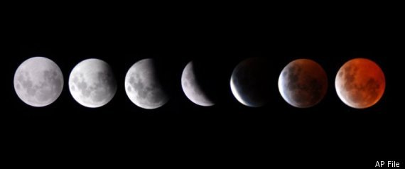
Lunar eclipse to avert North America: One of the longest lunar eclipses in recent memory will take place today, with a viewing time of near 100 minutes. Unfortunately, the eclipse won't be viewable from North America, with the eclipse starting at 1:24pm, and totality occurring at 3:22pm (smack in the middle of the afternoon). The eclipse will be the longest since 2000, thanks to a great alignment of the earths shadow and the moon, meeting where the earths shadow is the widest, hence the longer totality time (3:22 pm to 5:02pm EDT). So stoked for the eclipse, but live in North America? You can still check it out. Thank goodness for the internet! Check out a live stream here, courtesy of NASA and Huffington Post Online. Happy viewing! Featured Image: NASA/AP photo of the projected eclipse view.

Article by John Homenuk. Written June 15th, 2011 at 2:02pm. Looking for a forecast? See New York Metro Weather's Long Range Forecast for the end of the week into the weekend, or view our Technical Forecast Discussion for the more serious weather enthusiasts. Also, check out our new Forecast Overview tab. For up to the minute details on forecasts, watches, warnings, and alerts, follow us on Twitter and Facebook.