***WE HAVE MOVED TO A NEW WEBSITE. You will be automatically redirected to our new location in 5 seconds.
Showing posts with label 2011. Show all posts
The 5th warmest November on record in New York City now a memory, December began with a much cooler airmass in place behind a cold front. The next few days will offer much of the same, as clear skies and full sun will only be able to produce highs near 50 on both Friday and Saturday. This is thanks to a Canadian high pressure which is built in over the area. The cold air comes as a drastic change from the last week of November, which offered record setting highs. Temperatures will rebound a bit on Sunday as a ridge builds in the mid-levels of the atmosphere and the airmass over the area modifies. Without any new cold air source, it is expected that temperatures will rise each day as we work towards the new week. Winds will still be a bit breezy on Friday, but not as strong as Wednesday or Thursday. Overnight lows will still drop into the 20's and 30's until Saturday Night, when they will start trending a bit warmer. Pictured right: The NAM Model showing high pressure built in over the area this weekend.

THE FORECAST AT A GLANCE...

Today (Friday): Sunny, with a high near 53. West winds between 10 and 15 miles per hour.

Tonight: Partly cloudy, with a low around 35. North winds between 5 and 10 miles per hour.

Saturday: Sunny, with a high near 49. North winds around 10 miles per hour.

Sunday: Mostly sunny and milder, with a high near 56. Overnight low near 44.

METEOROLOGICAL WINTER BEGINS...

Meteorological winter began yesterday, December 1st 2011. If you're like us, this usually means exciting and challenging times are ahead as snowstorms and associated systems are closer to impacting the forecast area. This can be one of the most humbling times of the year for a weather forecaster. Our latest Technical Featured Discussion details our thoughts on the first two to three weeks of the meteorological winter, leading us towards the holiday weekend. Check it out by clicking here, and leave us a reply to let us know what you think!

Article written by JH. Published December 2nd, 2011 at 12:15am. Looking for a forecast? Use our new Forecast Beta tool to see the latest forecast in your specific area for the upcoming weekend, or view our Technical Forecast Discussion for the more serious weather enthusiasts. Also, check out our new Forecast Overview tab. For up to the minute details on forecasts, watches, warnings, and alerts, follow us on Twitter and Facebook.  
In case you haven't heard yet, the New York Yankees are gearing up for the 2011 American League  Division Series which will be played beginning this Friday in the Bronx. During the stretch of the regular season the Yankees have experienced a tremendous amount of weather related delays, game impacts, and postponements. Ultimately, these weather related impacts (although seemingly small at the time), have had impacts on the team during the season including doubleheaders and shortened/adjusted travel time. All of that said, Autumn is what we like to call a "transition season" here in New York City. The pattern is changing, and the weather can abruptly change as well. This time of year often brings the potential for some nasty weather (remember the Angels wearing the face masks to keep warm in the 2009 ALCS?....yeah), and it's our job to keep you updated on what's happening. Whether you're headed out to the stadium, expected to be out and about that night, or simply looking to check up to see if there's any problems expected, this is your place to be. 


The bad news, at the current time, is that the atmosphere looks to be unsettled during the first two games at Yankee Stadium. The details are below...


THE FORECAST...

Friday (Game 1): Game time temperature: ~70°, falling. Game time winds: S, 10mph

To keep it simple, there are two cold fronts that are forecast to pass the area. The first is passing through Thursday evening. There could be a period of heavy rain with this front. Behind it, winds will kick up a bit out of the south through Friday afternoon. The second front will be near the area around game time. It is hard to say at this time whether or not this front will produce some scattered showers and thunderstorms. It may very well pass the area without much notice, or it may touch off storms that could impact the area around the 830pm start time. One thing working in our direction: moisture in the atmosphere will be less, because of the first front passing in the morning. We will be watching carefully!


Saturday (Game 2): Game time temperature: ~60°, falling into the low 50's during game. | 

The airmass will be much cooler by the time Game 2 of the ALDS rolls around on Saturday. There is a chance, again, for scattered showers. The front will be to the east of the area, but the atmosphere will still be unstable and unsettled. This will be a situation where we will have to watch carefully as the day goes on to see what's developing. By the latter half of the evening (later in the game), the air will be cooler, and temperatures by evening should fall into the 50's. Northwest winds, and a cool high pressure building in, will make it feel like October baseball for sure. 
In case you haven't heard yet, the New York Yankees are gearing up for the 2011 American League Division Series which will be played beginning this Friday in the Bronx. During the stretch of the regular season the Yankees have experienced a tremendous amount of weather related delays, game impacts, and postponements. Ultimately, these weather related impacts (although seemingly small at the time), have had impacts on the team during the season including doubleheaders and shortened/adjusted travel time. All of that said, Autumn is what we like to call a "transition season" here in New York City. The pattern is changing, and the weather can abruptly change as well. This time of year often brings the potential for some nasty weather (remember the Angels wearing the face masks to keep warm in the 2009 ALCS?....yeah), and it's our job to keep you updated on what's happening. Whether you're headed out to the stadium, expected to be out and about that night, or simply looking to check up to see if there's any problems expected, this is your place to be. 

We'll be adding graphics, information, etc as we draw closer to Game 1 (and onward), so make sure to check back often.

FIRST LOOK AT THE FORECAST...

Friday (Game 1): Game time temperature: ~70°, falling during game. | Game time winds: South, 10 mph.


To keep it simple, there are two cold fronts that are forecast to pass the area on Friday. The first, which we are more confident in, will pass Friday morning. There could be a period of heavy rain with this front. Behind it, winds will kick up a bit out of the south through Friday afternoon. The second front will be near the area around game time. It is hard to say at this time whether or not this front will produce some scattered showers and thunderstorms. It may very well pass the area without much notice, or it may touch off storms that could impact the area around the 830pm start time. One thing working in our direction: moisture in the atmosphere will be less, because of the first front passing in the morning. We will be watching carefully!

Saturday (Game 2): Game time temperature: ~60°, falling into the low 50's during game. | Game time winds: Northwest, 10 mph.


The airmass will be much cooler by the time Game 2 of the ALDS rolls around on Saturday. There is a chance, again, for a scattered shower..but they will be less widespread. The air will be cooler, and temperatures by evening should fall into the 50's. Northwest winds, and a cool high pressure building in, will make it feel like a beautiful night for October baseball in the Bronx. 

Article published September 28th, 2011 at 1:17am. For up to the minute details on forecasts, watches, warnings, and alerts, follow us on Twitter and Facebook. 

Summer 2011 average temperature (through August 31st)
We love summer, there's no denying it. So it's with heavy hearts that we had to compile the recap of this past summer, as we begin the transition in to fall. Don't worry, we actually love all seasons, but it's definitely harder to let go of the beautiful weather which summer often has to offer. This summer was no different.  As we take a look back, we'll begin to see that it was essentially a summer of two tales, and the last month of the summer became quite anomalous. In fact, much of the summers precipitation was recorded in August and September. The last week of June (when summer begins) into roughly the middle to end of July was not exactly a drought, but definitely featured most of the summers hot days and a general lack of heavy precipitation. Our area observed multiple 100 degree days in July, including one record breaking day on July 22, which saw Newark, NJ set it's all time record high temperature at 108 scorching degrees. Before we continue, we most note that these numbers are not final and do not include the 19 days of September, which technically will factor into the final summer departures and averages. 

TEMPERATURES...

Departure from average temperature (through Aug 31)
To cut straight to the good stuff, Summer 2011 was another above average summer, marking the second in a row since the absolute scorcher that was the Summer of 2010. Average temperatures through August 31st were over 76 degrees in the New York City Metro area. The summer of 2010, for comparison purposes, offered very similar average temperatures, but these high averages were more spread out across the entire Northeast. This summer, there was a sharp gradient over the interior and areas to the North and West. In fact, to our north over New England, average temperatures were nearly 10 degrees cooler.

Temperature departures this summer were generally 2 to 3 degrees above normal throughout the entire area. There were several factors that lead to this--but essentially, the warm start of the summer had our area at nearly 5 degrees above normal as we entered August. However, the relatively average and somewhat cooler month of August knocked down the above average departures to more mediocre levels. In fact, areas of Northwest New Jersey and Southeast New York saw temperature departures of 1 to 2 degrees below average during the month of August, after experiencing a scorching hot July with the rest of us.

Overall, this summer featured temperatures moderately above average, but nearly 2 degrees "cooler above average" than the summer of 2010. On the opposite end of the spectrum, the summer of 2009 ended with temperatures 1 to 3 degrees below average. It has been a tale of three completely different summers over the last three years in our area for sure.

PRECIPITATION...


With the ridge of high pressure built in, providing the historic levels of heat (we mentioned the 105+ degree numbers earlier) and above average temperature departures early in the summer, also came a drier than normal month of July throughout the area. It almost comes with the territory, when you're talking about multiple 100 degree days. As our area began to head into August, precipitation departures were nearly 3 to 5 inches below normal across much of the forecast area. Essentially, the persistent ridge of hot weather and high pressure which was built in over the Central Plains (we are sure you have heard of the historic heat this summer brought them) was flexing it's muscles during the first half of the summer across our area, leaving us generally drier and warmer than normal. Most of our precipitation through August 1st came in the form of scattered showers and thunderstorms, and the occasional extended period of rain along a warm front.

None of us, however, could have seen August coming. In what would become the wettest month in recorded history at New York City, we not only erased the negative precipitation departures, but posted major gains. Our area received over 300 percent of our normal precipitation in the month of Augustand we ended the summer with a departure of +10 inches from normal precipitation. Areas near Northwest New Jersey received nearly 15 inches of normal precipitation over the summer. The pattern change from the first half to the second half of the summer in regards to precipitation was truly amazing (and historic) to watch unfold.

WHAT CAN 100 DEGREE DAYS TELL US ABOUT WINTER?


NYC snowfall after multiple 100 degree days in previous summer
Credit: Yehuda Hyman
Meteorology is not only about learning from the past events, but also looking to the future. So, you may be asking yourself: what can we learn from summer, that may help us get an idea as to what the winter has to offer? The answer, really, is that the summer can more often than not be a toss up when it comes to being of direct relation to winter forecasting. Much more answers lie in the autumn season, as the pattern begins to change, and we begin to get an idea of the atmospheric transitions which are occurring (see our sea ice level post from this evening). Still, with this being the second summer of multiple 100+ degree days in New York City, we pulled out the statistics for snowfalls after such events in the summer. Having multliple 100 degree days is a rare enough event in New York City itself that we haven't seen it in back to back years since 1953. The last time we saw it, prior to last summer, was 1999, and that winter offered less than 20 inches of snowfall.

However, if the winter of 2010 has anything to say about what's to come, we may be in for another long winter. Additionally, the average snowfall after the previous summer featured multiple 100+ degree says is over 30 inches, higher than the normal average snowfall. So, there may be some argument over time that summer which feature these heating days may be foreshadowing an above average winter. The truth is, we don't truly know what to expect at this point. The spread is too large among the data we've compiled. We'll just have to watch carefully over the next several weeks as we head into autumn, as father time begins to transition us into another one of the four seasons we have the privilege of experiencing in our area.


Article written by John Homenuk, with contributions from Yehuda Hyman. Published September 19th, 2011 at 11:37pm. Looking for a forecast? See New York Metro Weather's Long Range Forecast for current work week, or view our Technical Forecast Discussion for the more serious weather enthusiasts. Also, check out our new Forecast Overview tab. For up to the minute details on forecasts, watches, warnings, and alerts, follow us on Twitter and Facebook. 
NAM model showing 40 degree lows Friday morning
A significant mid level disturbance is forecast to drop southeast from Central Canada later this week, bringing with it the coldest air of the past several months. You may hear those words a lot, but in reality we have not seen air like this since March of 2011. The disturbance is drawing upon cold air which has been building in North-Central Canada for several weeks, and although the air will not be as cold as it was there, overnight low temperatures are likely to be shockingly cool if you live in the interior. A cold front is poised to cross the forecast area Thursday afternoon, and after some showers and thunderstorms, a rapid temperature drop will occur. Winds will shift from southwest to northwest (and gusty, at that). Temperatures are forecast to fall from the mid 80's to the mid 40's overnight. In fact, temperatures in the interior higher elevations may drop into the upper 30's to low 40's early Friday morning (before sunset).

The cool airmass will remain in place Friday and Saturday, with high temperatures forecast to top out in the middle to upper 60's and upper 60's to near 70 respectively. In addition, the rapid drop in dew points will make the air feel much more crisp and clear--it's really going to begin to feel like autumn later this week. Essentially, Wednesday looks to be the last day (for a while at least, we can't rule anything out yet) to get out and enjoy the warm sun this week. It should be noted that record low temperatures are in the mid 40's throughout most of the city, so it will likely be difficult to break the records (hence the post title "near record breaking cold")...but the change in airmasses will be dramatic. Stay with us over the next few days as the airmass changes and the autumn feel floats through the air.

Article written by John Homenuk, September 13th, 2011 at 11:53pm. Looking for a forecast? See New York Metro Weather's Long Range Forecast for the work week, or view our Technical Forecast Discussion for the more serious weather enthusiasts. Also, check out our new Forecast Overview tab. For up to the minute details on forecasts, watches, warnings, and alerts, follow us on Twitter and Facebook.
NAM model showing temperatures in the 20's Wednesday
morning over the Northern Plains. 
Often times, it goes unappreciated. Most times, it becomes a subconscious way of life. However, if one were to take a look back at the diverse nature of the weather we experience in this part of the country, they would be surprised. Our area does not fall under the typical definition for a center of "severe weather". Still, this last calendar year has offered it all. From tornadoes in New York City last September 2010, to the record breaking winter of 2010-2011, to a summer which set records for above average temperature anomalies, all finally topped off by an earthquake felt on the east coast, and the severe impacts of Hurricane Irene. It has been a wild ride in our area. Yet, one thing remains consistent. Four times a year, the calendar switches to a new season. Whether it be Summer, Autumn, Winter, or Spring, the conditions which surround our daily lives change, so dramatically that we lose over 5 hours of sunlight in a 4 month period. This month, Autumn will officially begin on September 21st. Last month, we were still experiencing temperatures well into the 90's. Those seem like an incredibly distant memory, especially now, after a historic month of rainfall..where New York City set it's record for most rainfall observed in a month, ever. 

NAM model showing mid level
disturbance bringing cold air over
Northern US. NYC area is highlighted
in orange. 
Now, the season's changes are finally being observed on forecast models, which are showing the first true "cold front" since the Spring. A large upper level disturbance is forecast to move into the Northern Plains during the middle part of this week, and it will be carrying a ton of cold air with it. In fact, temperatures (in the image above) are forecast to drop into the 20's in the Northern Plains. And it's still technically summer! Although that statement probably only adds credence to the meteorological calendar (where autumn began on September 1st), it's more of a sign of change for us. It's the first time we're seeing the cold air, which will eventually engulf our entire area in just a few short months, enter the United States. Although the upper level disturbance won't provide this anomalous cold air to us (see the image to the left), the main culprit in the upper level disturbance we discussed earlier will move just to our north and west. This will allow temperatures later this week to fall into the 60's for high's and potentially lower 50's for lows. It could even drop into the upper 40's in the inland areas or higher elevations. 

This time of year often isn't welcomed by those who are hanging on to the last touch of warm air that the summer sun has to offer. Yet, it's definitely more prudent to enjoy the diverse and ever-changing weather that our part of the world has to offer. To be able to experience such diverse weather is a gift and a curse at the same time, as the changing patterns often bring severe weather ramifications. Still, the weather has something to offer for everyone, and in the coming month's the hands who hold it's favor will change once again, as they do every three months. We hope you'll stick around with us for the ride, there's a long autumn and winter in front of us. 

Article written by John Homenuk, September 12th, 2011 at 12:10am. Looking for a forecast? See New York Metro Weather's Long Range Forecast for the work week, or view our Technical Forecast Discussion for the more serious weather enthusiasts. Also, check out our new Forecast Overview tab. For up to the minute details on forecasts, watches, warnings, and alerts, follow us on Twitter and Facebook.

NAM model showing winds off the
ocean Sunday afternoon. 
A back door cold front is making it's presence known in the forecast area this morning, and will continue to  do so through the remainder of the day. A back door cold front gets it's name from it's origin, which is to our east or northeast. Normal cold fronts enter the area from the west or northwest. Back door cold fronts usually bring maritime air into the area and winds off the water, and this one will be no different  Although it won't be a washout the front will still bring in cooler air off the ocean. In addition, increased humidity and cloudiness will enter the forecast, making for less than ideal conditions today. A chance of showers and thunderstorms will exist throughout the area beginning this morning and continuing through all of Sunday, although the precipitation should be more showery than steady as mentioned earlier. The atmosphere won't be unstable enough to support many thunderstorms. It won't be continuous or non-stop, but it definitely will be noticeably different than Friday and the first half of Saturday, which offered temperatures into the 80's. 
THE FORECAST...


Today (Sunday): Mostly cloudy, with a chance of scattered showers throughout the day. East winds and overcast skies will keep temperatures down into the middle 70's. The air will feel much cooler than the past few days, but it should still be relatively humid. 


Tonight (Sunday Night): Continued mostly cloudy skies with a chance of showers as the back door cold front holds on through the overnight period. Temperatures dropping into the mid 60's throughout most of the area. Bring long sleeved gear to stay warm if you're going to be out and about. 


An early look ahead to the week: Some clearing is forecast by early next week, but the main story that we're looking ahead to is the potential for our first "fall like" cold front, which could enter the area by the middle to later part of the week. If it does come to fruition, the dew points would lower greatly and the air would feel crisp and fresh for the first time in a while. We'll see! 


A FINAL NOTE...


Although we prefer not to indulge into national events, in a day in time when political stances are often extremely over analyzed, today is a bit different. The world changed permanently 10 years ago today, and whether you agree or not with our countries strategical decisions since then, today is a day for us to recognize the heroes which are among us still. Not only were there thousands of heroes in our own city 10 years ago, there are still hundreds of thousands of heroes fighting for our freedom today. Without them, much of what we do on a daily basis would not be possible.


So, take a moment today to think about their sacrifices. Take a moment to say thank you for what they've done and continue to do. We wish we could thank each and every one of them in person, but instead we have a blog post. Although words can only say so much, we will use them to say thank you, and God bless America. 


Article written by John Homenuk, September 11th, 2011 at 1:16am. Looking for a forecast? See New York Metro Weather's Long Range Forecast for the weekend into next week, or view our Technical Forecast Discussion for the more serious weather enthusiasts. Also, check out our new Forecast Overview tab. For up to the minute details on forecasts, watches, warnings, and alerts, follow us on Twitter and Facebook.
Total Precipitation over the last two days in NY State
Although the rain has ended across our area, thousands are still struggling over Pennsylvania and  New York State as massive floods have inundated the states. Nearly 100,000 people have been ordered to evacuate amidst a three day period of nearly non-stop heavy rain in association with the remnants of Tropical Storm Lee. The Susquehanna River is one of the main culprits in the severe flooding which is still occurring. The heavy rain has put the river well over flood stage, and the water continues to rise. The latest update from The US Geological Survey and the National Weather Service has the river at 25.06 feet. The flood stage for the river is 17.0 feet. The river is forecast to reach a maximum height of 27 feet within the next two days. For now, it appears the torrential rain has ended, but the flooding will continue. The floods extend northward into New York State, where areas such as Binghamton have been dramatically flooded. The Susquehanna River at Binghamton set a new height record, reaching 25.71 feet. The old record was 25.0 feet.

THE REASON FOR THE RECORDS...

Susquehanna  River heights at Binghampton (9/8/11)
The culprits behind the extreme flooding along a corridor near the Susquehanna River this week were multi-faceted. First, the remnants of Tropical Storm Lee came ashore last weekend, and moved northward into the Mid-Atlantic. Second, a disturbance over the Great Lakes slowed down the remnants and interacted with them, forcing the development of an upper level "cutoff" low. Essentially, a disturbance in the atmosphere stalled and became it's own entity over the Tennessee Valley and Mid-Atlantic. Moisture from the Atlantic Ocean was streaming in from as far south as Florida and the Southwest Atlantic Ocean along a stalled frontal boundary which was situated near the Susquehanna River. The result was the development of extremely heavy "training" (or near constant over the same areas) rainfall in these areas, which continued for nearly three days.

CAN IT GET ANY WORSE?

Over the next few days, although the rain will taper off as the disturbance weakens and then shifts east, the rivers and creeks which have been affected will likely still be rising, at least initially. The flooding will continue over the areas affected, so the mandatory evacuations will remain in effect. If you live in any of those areas, please wait to return to your homes safely. Iif you have any reports, pictures, videos, or observations to send us, don't hesitate. We can use each and every one of them.

Article written by John Homenuk, September 8th, 2011 at 11:35pm. Looking for a forecast? See New York Metro Weather's Long Range Forecast for the current work week and weekend, or view our Technical Forecast Discussion for the more serious weather enthusiasts. Also, check out our new Forecast Overview tab. For up to the minute details on forecasts, watches, warnings, and alerts, follow us on Twitter and Facebook.
The last few days have offered very little hope for those wishing to see the warm summer sun, but the good news is that the stretch of poor weather is nearly over. The low pressure system responsible for the relentless rain and overcast skies is slowly shifting eastward away from the area, and will begin to lose it's grip by Tuesday. Some scattered showers and thunderstorms may still develop during the afternoon hours, but the rain will not be as widespread or steady--and most importantly, won't be around for the entire day. The system is then forecast to shift east by Tuesday night--leaving our area with mostly clear skies, and a pleasant forecast for the end of the week. Temperatures should rebound towards normal by Wednesday and Thursday. Featured video: Video forecast discussion for August 16th, 2011, detailing the day in weather and the specific threats for potential thunderstorms and heavy rain. Courtesy of the forecasting team.

Forecast in Detail: Tuesday morning will likely offer a chance of some breaks in the clouds and the potential for some sun. The sun will be in and out, though, and not consistently bright. By afternoon, scattered showers and thunderstorms will develop bringing the chance for heavy rain, lightning, and thunder. The evening is expected to bring gradual clearing, with the storm system shifting east. High temperatures will be warmer than the past few days, reaching towards 80 degrees in the afternoon. We'll drop into the 60's again overnight into Tuesday morning, though, as a slightly cooler and noticeably calmer airmass settles in.

A Look Ahead: The middle to end of the week looks to offer a return to more pleasant weather, with high temperatures averaging near normal on Wednesday and Thursday. The next chance of rain will rear it's head on Thursday afternoon and Friday, when a frontal boundary near the region could very well spark off showers and thunderstorms. The storms could be more widespread on Friday, offering a chance for more rainfall.

Article written August 16th, 2011 at 12:30am. . Looking for a forecast? See New York Metro Weather's Long Range Forecast for the upcoming week, or view our Technical Forecast Discussion for the more serious weather enthusiasts. Also, check out our new Forecast Overview tab. For up to the minute details on forecasts, watches, warnings, and alerts, follow us on Twitter and Facebook.
The low pressure system responsible for the prolific rainfall observed in the area on Sunday will still be meandering around the forecast area Monday, bringing with it a chance of showers and thunderstorms which could be widespread at times. The rainfall on Sunday was as historic as it was relentless, with Kennedy Airport in Queens observing a new all time record for daily rainfall (7.76 inches), breaking the old record set in 1983. Several reporting stations throughout the metro recorded rainfall totals in excess of 6 inches. Some personal weather stations in Long Island (Nassau County) recorded rainfall amounts over 10 inches by late Sunday evening, with the rain still continuing to fall at a moderate to heavy pace over much of Long Island, Southeast New York, and portions of Connecticut. The rain is forecast to continue on and off through Monday afternoon, although the more steady precipitation may actually be focused east of the city. Featured video: Video Forecast Discussion for Monday August 15th, 2011, from the forecasting team.

Forecast in Detail: The rain will continue to be a threat throughout Monday as the surface low pressure system passes east of the region. Although not as widespread or relentless as Sunday, the showers and thunderstorms will be capable of producing moderate to occasionally heavy rain, which could cause rapid street flooding, especially to areas already flooded or moistened by the heavy rains on Sunday. By Monday Night, the precipitation should become much more spotty, with a few showers meandering around the area.

Tuesday is forecast to feature a welcomed return to dry conditions, with the sun finally returning to the forecast and high temperatures crawling back into the low 80's. Winds will be light and out of the west.  

A Look Ahead: The middle to end of the week looks to offer a return to more pleasant weather, with high temperatures averaging near normal on Wednesday and Thursday, and only a slight chance of an isolated shower or thunderstorm. The next chance of precipitation looks to come on Friday with the passage of a cold front.

Article written August 15th, 2011 at 12:10am. . Looking for a forecast? See New York Metro Weather's Long Range Forecast for the upcoming week, or view our Technical Forecast Discussion for the more serious weather enthusiasts. Also, check out our new Forecast Overview tab. For up to the minute details on forecasts, watches, warnings, and alerts, follow us on Twitter and Facebook.
A low pressure system developing near the area has become the focal point for very heavy rain, which continues to affect the area this Sunday morning. Through 800am, prolific rainfall amounts were already recorded throughout much of the forecast area. Kennedy Airport recorded 5.61 inches of rainfall, LaGuardia airport recorded 3.88 inches of rainfall, Newark airport recorded 3.27 inches of rainfall, and Central Park recorded 3.20 inches of rainfall. With the rain continuing over the next several hours, these rainfall totals could become quite prolific throughout the remainder of the day. Please remember that flooding is a serious severe weather event. The National Weather Service has issued Flash Flood Warnings for a vast majority of the forecast area including much of New Jersey, New York and Pennsylvania. Featured video: Severe Weather Briefing from August 14th, 2011, issued by New York Metro Weather's forecasting team.


Forecast in Detail: The rain will continue through the remainder of today, without many serious breaks in the action. The low pressure system is forecast to consolidate off the coast, likely leading to a well developed area of moderate precipitation expanding over the area. While the area has not had the luxury of a normal precipitation summer (many areas below normal through today), these type of rain events are almost always a problem, especially as flooding potential develops as the rain continues for extended periods of time. Plus, the weekend timing is less than ideal.

Monday should feature, at least to start, more of the same although the showers could become a bit more spotty over Long Island. The rain could continue over New Jersey and New York through the mid to late afternoon. After that, model guidance begins to wrap up the event with precipitation ending from southwest to northeast.

A Look Ahead: The middle to end of the week looks to offer a return to more pleasant weather, with high temperatures averaging near normal on Tuesday and Wednesday, and only a slight chance of an isolated shower or thunderstorm. The next chance of precipitation looks to come on Friday with the passage of a cold front.

Article written August 14th, 2011 at 11:10am. Updated at 1:53pm to include severe weather briefing video. Looking for a forecast? See New York Metro Weather's Long Range Forecast for the weekend into next week, or view our Technical Forecast Discussion for the more serious weather enthusiasts. Also, check out our new Forecast Overview tab. For up to the minute details on forecasts, watches, warnings, and alerts, follow us on Twitter and Facebook.
This Spring has certainly been one of variance, marked by several wild swings in sensible weather over short periods of time. We've already seen two bouts with oppressive heat (one officially noted as a heat wave per the National Weather Service), and two periods of below average temperatures directly afterwards. The general idea seems to continue in the short term. With the last few days settling below average in the temperature department, forecast models are beginning to show the first hints of a return to a warmer pattern. Today, thus far, has been above normal at some stations, with temperature readings in the low to mid 80's (averages in the upper 70's to 80). Thursday should feature much of the same, and may even be a hint warmer. However, Friday will feature more unsettled weather with a storm system rounding the base of an ejecting upper level trough over the Northwest Atlantic Ocean. The good news? This feature moves northeast fairly quickly, setting the stage for a warming weekend with temperatures in the mid 80's--and only widely scattered chances of thunderstorms. Looking deeper into the future,  forecast models try to bring 90 degree readings back into the forecast by the middle of next week (yeah, we're excited too). Featured image: Current temperatures throughout the Mid-Atlantic states courtesy of Rutgers Weather Net.

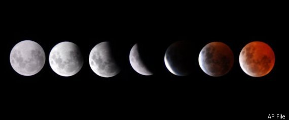
Lunar eclipse to avert North America: One of the longest lunar eclipses in recent memory will take place today, with a viewing time of near 100 minutes. Unfortunately, the eclipse won't be viewable from North America, with the eclipse starting at 1:24pm, and totality occurring at 3:22pm (smack in the middle of the afternoon). The eclipse will be the longest since 2000, thanks to a great alignment of the earths shadow and the moon, meeting where the earths shadow is the widest, hence the longer totality time (3:22 pm to 5:02pm EDT). So stoked for the eclipse, but live in North America? You can still check it out. Thank goodness for the internet! Check out a live stream here, courtesy of NASA and Huffington Post Online. Happy viewing! Featured Image: NASA/AP photo of the projected eclipse view.

Article by John Homenuk. Written June 15th, 2011 at 2:02pm. Looking for a forecast? See New York Metro Weather's Long Range Forecast for the end of the week into the weekend, or view our Technical Forecast Discussion for the more serious weather enthusiasts. Also, check out our new Forecast Overview tab. For up to the minute details on forecasts, watches, warnings, and alerts, follow us on Twitter and Facebook.