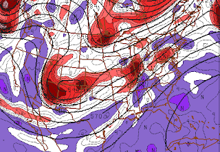
 The long stretches of relatively calm and benign weather are likely to be in the rear view mirror over the next week or so, as a very active weather pattern sets up over the Eastern 1/3 of the United States. A frontal zone will set up near the area beginning the middle of this week, serving as a relative highway for low pressure areas to track along. The first storm system will approach the area Wednesday Night, with showers likely throughout much of the area. Precipitation type isn't expected to be much of a problem with this one, although some sleet may mix in over Northern areas early in the storm. Clear weather will briefly build in on Thursday, but another storm system is expected to track near or just south of the area on Thursday Night through Friday morning. This system could offer more problems as far as precipitation type, especially away from the immediate coast. Some snow and sleet are definitely possible, with light accumulations. Near the coast, mostly cold rain is expected. Yet another storm system could approach the area beginning Christmas Eve (we know, this is getting rather repetive isnt it?) with precipitation problems once again expected away from the coast. There is a ton of uncertainty here, as the exact track and strength of the system will determine where the chips fall as far as precipitation type. Accumulations should generally be light to moderate, nothing overly significant, but could still cause some travel headaches. One thing is for sure, we will be here to keep you updated! Pictured right: NAM model showing an extremely active pattern across the United States, with several areas of energy poised to affect the region.
THE FORECAST AT A GLANCE...
Tuesday: Partly sunny, with a high near 46. North winds generally around 5 miles per hour.
Tuesday Night: Increasing clouds. Low near 39. Winds turning east, around 5 miles per hour.
Wednesday: Rain likely, with a brief period of sleet or snow possible in the interior and highest elevations. Winds south around 10 miles per hour. High near 53. Chance of precipitation is 80%. New precipitation amounts between 0.25" and 0.50" expected.
Article written by JH. Published December 19th, 2011 at 10:!4pm. Looking for a forecast? Use our new Forecast Beta tool to see the latest forecast in your specific area for the remainder of the week, or view our Technical Forecast Discussion for the more serious weather enthusiasts. Also, check out our new Forecast Overview tab. For up to the minute details on forecasts, watches, warnings, and alerts, follow us on Twitter and Facebook.
Comments
0 Response to 'Active pattern as we approach holiday weekend'
Post a Comment